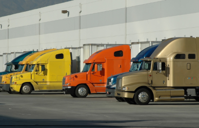

Every driver knows the reality. You can plan your clock perfectly and still burn time hunting for a safe place to shut down. Even a brand-new mega lot with hundreds of spaces barely scratches the surface of the nationwide truck parking shortage. That is why more attention is shifting toward data-driven tools that show where drivers actually stop when hours are running out.
Instead of guessing, technology platforms are now mapping real parking behavior from Class 8 trucks across the country and using that information to guide future investment.
Why Smaller Parking Locations May Matter More Than Mega Lots
Chris Oliver, chief marketing officer at Trucker Path, believes the solution is not always massive parking developments.
“A big piece of land with 500 truck parking spaces might knock a tiny dent in the national truck parking crisis in America,” Oliver said. “Then you’re more likely to be where the driver needs you to be when you need to be there. As those hours of service start to weigh down, you’re not always a half hour away from a giant parking location with 500 spots. You’re often in different places, so having smaller pockets more ubiquitously placed across the geography is, in my opinion, the answer.”
That idea lines up with what drivers experience daily. Parking demand is spread out, especially along ramps and corridors where trucks naturally shut down when clocks expire.
Truck Parking Remains a Top Industry Pain Point
The shortage is not anecdotal. Truck parking ranked as drivers’ second biggest concern and carriers’ ninth biggest concern in the American Transportation Research Institute’s most recent Top Industry Issues list.
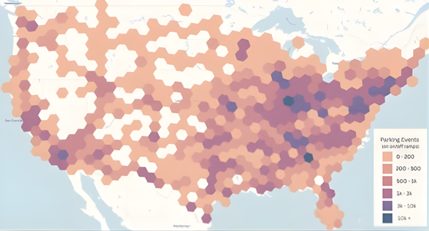
Data from the Altitude by Geotab platform shows just how widespread the problem is. Between November 1, 2024, and October 31, 2025, there were approximately 330,000 long-duration heavy-duty truck parking events on interstate ramps nationwide. Indiana, Illinois, and Tennessee topped the list by state, while Atlanta, Indianapolis, and the New York Newark area ranked highest among metro regions.
That data is increasingly important as more than 200 million dollars in federal funding has been set aside specifically for expanding truck parking infrastructure.
How Parking Data Is Being Collected and Analyzed
Trucker Path relies heavily on driver participation. The app currently lists about 29,000 truck parking locations. When drivers enter or exit those areas, the app prompts them to report availability.
According to Oliver, drivers digitally visit those locations about 27 million times per month and submit roughly 1.9 million parking availability reports monthly.
“Parking locations and their availability are one of the most clicked upon data points within Trucker Path, and it’s also the most shared crowdsourced information that we have,” Oliver said.
On the analytics side, Altitude by Geotab pulls from more than 100 billion data points across its vehicle ecosystem. Users can filter parking behavior by vehicle class, engine type, operation style, such as long haul or regional, industry segment, road type, and location. Thresholds can even be set to isolate stops lasting eight hours or longer.
“You can get that level of detail and really start pinpointing some of the context, rather than just anecdotally see a lot of trucks at a particular ramp,” said Nathaniel Veeh, associate vice president of business development at Altitude. “Rather than that, they could actually use that, plus the other measurements behind it to understand what’s actually going on and like, ‘okay, this is a smart investment for me.’”
The platform is used by public agencies and private companies to guide parking investments, inform regulations, improve route planning, and support driver retention.
Real-Time Parking Visibility Is Expanding
Another system, Streetline, recently completed its first year working with the Arizona Department of Transportation. During that time, it logged nearly two million parking events and delivered real-time space availability along Interstate 10.
Streetline reports a 95 percent accuracy rate using camera-based artificial intelligence, machine learning, and cloud analytics. The system accounts for changing weather, lighting, and traffic conditions and feeds information directly into transportation and traveler information platforms. It is now active in eight states.
“For truck drivers, reliable access to safe parking isn’t a convenience; it’s a critical necessity,” said Tony Bradley, president and CEO of the Arizona Trucking Association. “Over the past year, the I-10 Truck Parking Availability System has made a real difference by providing drivers with real-time information to schedule their daily breaks, support hours-of-service compliance, and make safer decisions at the end of a long day. We applaud the Arizona Department of Transportation and Streetline for delivering a viable solution that improves safety and gives drivers greater confidence on the road.”
Finding Parking Matters as Much as Building It
Even when parking exists, drivers still need to locate it in time. Oliver pointed to earlier ATRI research showing drivers spend up to 45 minutes per day searching for parking. Trucker Path’s own user survey from late 2025 found that the number dropped to 19 minutes when drivers used the app.
Trucker Path’s free version shows parking within a default radius. Paid users can see likely availability at upcoming locations based on historical patterns.
“There really are two sides to this,” Oliver said. “One is building enough spaces, which you know is happening and will take a while, but the other side is just making them discoverable and understanding if there’s really any parking there. That second side is where we come in … We’re not building parking spaces; we’re just making them discoverable.”
Source: Commercial Carrier Journal